|
||||||||||||||||||||||||||||||||||||||||||||||||||||||||||||||||||||||||||||||
The Progress of Our Georeferencing ProjectThe map below shows the points that have been georeferenced to-date. Of the 321,192 records that we have assigned to a particular continent or region, 112,983 (35%) have been georeferenced to 4158 unique localities. The map was downloaded from Online Map Creation, and dots plotted with iMap: Mapping Made Easy. The table below gives the breakdown by continent/region. This page was last updated on 31 March 2004. |
||||||||||||||||||||||||||||||||||||||||||||||||||||||||||||||||||||||||||||||


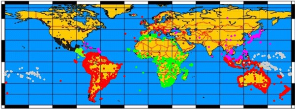
| Continent/Region | Records | Georef'd | Unique | % | |
| Australia | 28537 | 26875 | 1128 | 94% | |
| South America | 13207 | 11044 | 1047 | 84% | |
| Africa | 25997 | 19962 | 783 | 77% | |
| Oceana | 24115 | 18504 | 534 | 77% | |
| Central America | 9988 | 6930 | 252 | 69% | |
| Asia | 52032 | 15012 | 205 | 29% | |
| Europe | 17823 | 2797 | 33 | 16% | |
| Caribbean | 33209 | 5022 | 23 | 15% | |
| Middle East | 1658 | 164 | 8 | 10% | |
| North America | 114626 | 6673 | 145 | 6% | |
|
|
|||||
| Total | 321192 | 112983 | 4158 | 35% | |
We have worked our semi-automated georeferencing project by continent (or region), focusing on countries. We began with Africa and South America, continued with Australia and Oceana, and then have been working north along two fronts, Central America and Southeast Asia. Thus far, we have finished a first pass on 35% of the records.
What is next?
We have been using the GeoNet database to work those localities outside of the United States. We are now in the process of moving our semi-automated georeferencing system over to the USGS datbase to deal with the bulk of the records from North America.
As the first pass over these data is completed, we will begin our second passes. Again going country to country, but this time focusing attention on those localities that were not assigned geocodes during the first pass and those that are not mapping accurately.
This summer (2004), we will begin comparing the geocodes obtained from our semi-automated process to those from expedition charts and other sources to further test the accuracy of our records.